
Environmental Management MSc
Why choose this course?
The MSc in Environmental Management explores the exploitation of natural environments and the relationships between sustainable environmental management and natural ecosystems. It examines how sustainable environmental management and behaviour can be promoted and achieved.
The MSc in Environmental Management (Energy) examines current ideas in energy production, conservation, economic value and the essential "energy trilemma". Once you graduate, you will qualify for graduate IEMA professional status. You may also fast track to PIEMA (practitioner status) with completion of a work-based competence assessment. This can be a launch pad for future leadership roles.
The final masters award title will be reflected by your chosen pathway:
- Environmental Management MSc – this core pathway explores the rationale behind the exploitation of natural environments. It provides you with detailed knowledge and understanding of the important relationships between sustainable environmental management and natural ecosystems and the value of adopting an integrated approach to studying both.
- Environmental Management (Energy) MSc – this pathway is timely, nationally and internationally relevant, given the world's energy needs, as well as the surrounding political debates regarding fossil fuels and increasingly, renewables, which form such an essential component of the world's existence.
Environmental Management MSc
| Mode | Duration | Attendance | Start date |
|---|---|---|---|
| Full time | 1 year | Delivered two days a week (Wednesdays and Thursdays) |
September 2024 January 2025 |
| Full time | 2 years including professional placement | Delivered two days a week (Wednesdays and Thursdays) |
September 2024 January 2025 |
| Part time | 2 years | To be determined by which modules you decide to take in which teaching blocks. |
September 2024 January 2025 |
Environmental Management (Energy) MSc
| Mode | Duration | Attendance | Start date |
|---|---|---|---|
| Full time | 1 year | September entry - delivered in 3-day blocks of teaching, plus 1 day every week in teaching block 1. Delivered 2 days a week in teaching block 2. January entry - delivered 2 days a week in teaching block 1. Delivered in 3-day blocks of teaching, plus 1 day every week in teaching block 2. |
September 2024 January 2025 |
| Full time | 2 years including professional placement | September entry - delivered in 3-day blocks of teaching, plus 1 day every week in teaching block 1. Delivered 2 days a week in teaching block 2. January entry - delivered 2 days a week in teaching block 1. Delivered in 3-day blocks of teaching, plus 1 day every week in teaching block 2. Plus a placement year. |
September 2024 January 2025 |
| Part time | 2 years | To be determined by which modules you decide to take in which teaching blocks. |
September 2024 January 2025 |
| Main location | Penrhyn Road |
Reasons to choose Kingston University
- These courses meet the need for environmental professionals who understand the challenges of sustainable environmental management.
- Kingston has established active links with European and American universities, ensuring the courses are globally relevant.
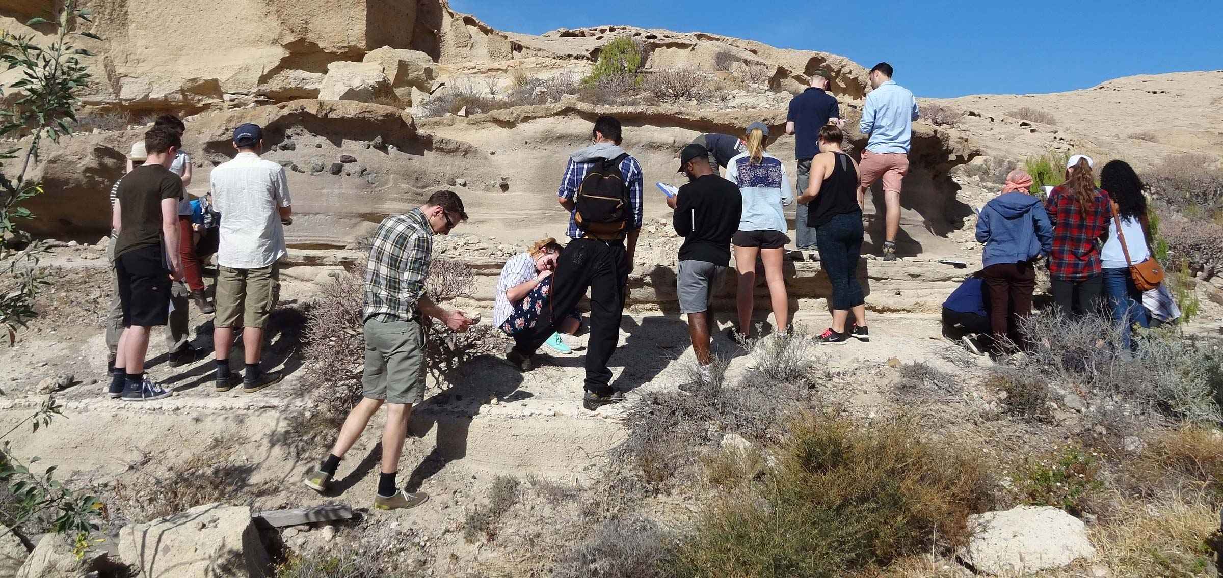
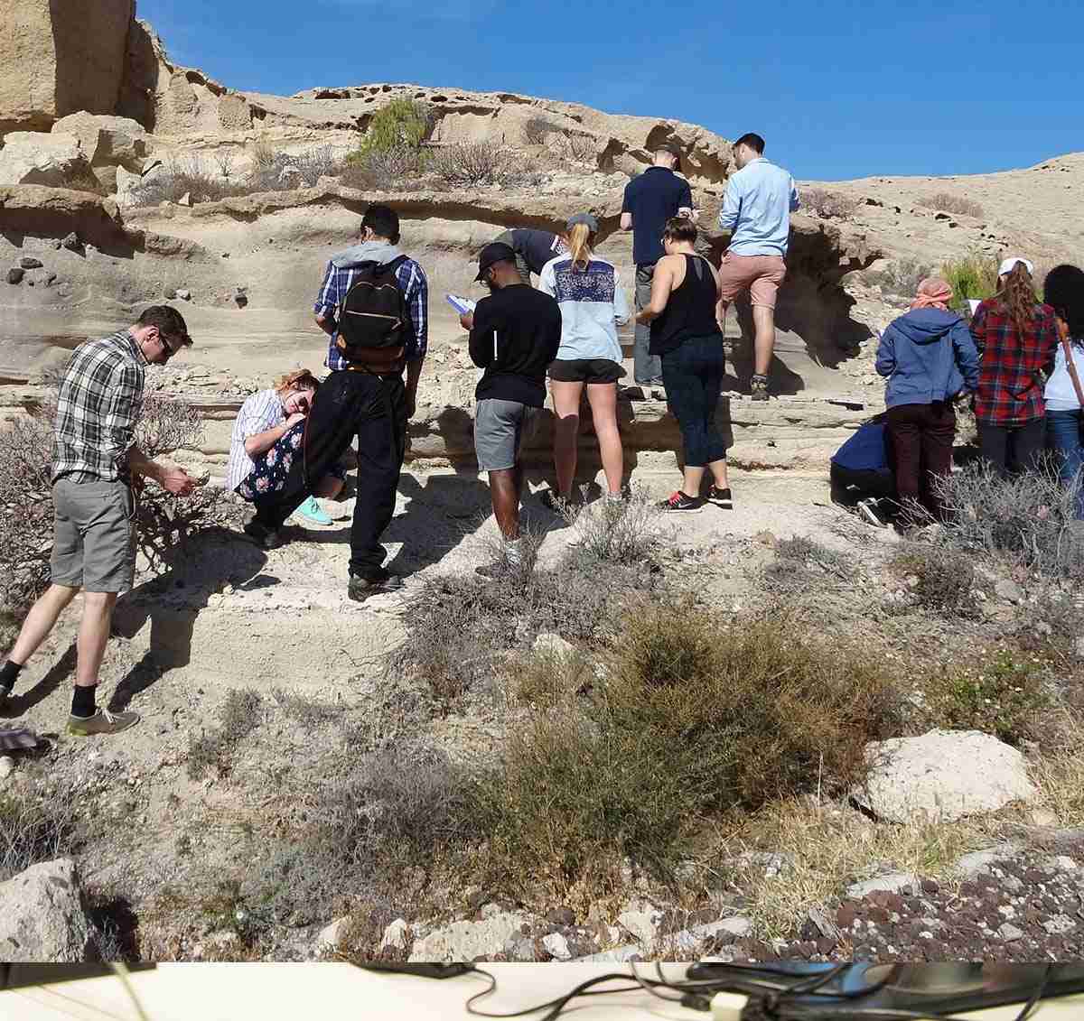
- These courses offer practical fieldwork experience.*
Please note: fieldwork will incur an additional cost. Details can be found in relevant module guides or from the course director.
* Students may be required to cover additional costs, such as travel.
Accreditation
This course is accredited by the Institute of Environmental Management and Assessment (IEMA). IEMA is the professional body for everyone working in environment and sustainability. This course entitles students to FREE student membership for the duration of the course and on successful completion you qualify for GradIEMA. Graduate membership is a launchpad for future leaders within environment and sustainability and offers a range of benefits to support you throughout your career. You can then "fast track" to Practitioner Membership.
What you will study
You will study the theoretical, practical and legal frameworks promoting sustainable environmental management and other drivers for sustainable behaviour at individual, institutional and governmental scales. You will learn how to innovate, respond to new and emerging challenges and work effectively in changing and unfamiliar situations.
The programme is made up of four modules, each worth 30 credits, and a research project module worth 60 credits. You will be able to choose from modules which explore aspects of sustainable environmental management, such as water, energy and land resources management and climate change.
For a student to go on placement they are required to pass every module first time with no reassessments. It is the responsibility of individual students to find a suitable paid placement. Students will be supported by our dedicated placement team in securing this opportunity.
Environmental Management MSc (Core pathway)
Environmental Management (Energy) MSc
Core modules
Environmental Management
30 credits
This module explores the motivations for, and paradigms of, 'sustainable development' at scales ranging from local to global including its grounding in economics, the social environment, in environmental politics and policy making as underpinned by law.
Contemporary level thinking around environmental governance is explored within SEM, using case examples from the UK, EU and US, including arrangements for command and control in pollution, payment for ecosystem services, market mechanisms and voluntary action. There are associated site visits. The module selects as major case examples from waste management (including energy recovery) and water management at the catchment scale. The module will come to focus on the application of Good Practice in the business sector at the local level and describe the operation of environmental assessment and appraisal (audits and impact analysis tools) such as Environmental Auditing, Eco-Design and Management and Environmental Audit (EMAS,) Environmental Management Systems (EMS), British Standards, Environmental Impact Assessment and Corporate Social Responsibility, Waste management and Eco-design.
Water, Energy and Land Resources Management
30 credits
This module examines the relationship between water, energy and land (including the WEL-nexus), associated environmental management challenges and sustainable management solutions. The module will develop an understanding and critical evaluation of these challenges at a variety of scales through the systematic investigation of the component challenges (water, energy and land), the interface between the components and their relationship to sustainable development.
Research Methods and Techniques
30 credits
This module provides basic skills in research methods and techniques, including geographical information system (GIS) for data storage, manipulation and display. It initially develops GIS skills by introducing GIS concepts, sources for geographical information and outlines basic spatial concepts. Subsequently the module encompasses the theoretical underpinnings to research methods and techniques, including sampling schemes, measurements, quality control issues, and data collection, manipulation and analysis. This together with practical elements of designing research proposals and data testing enables the necessary skills for carrying out independent research work.
On successful completion of the module, you will be able to:
- Evaluate the use of GIS in the capture, storage and handling, manipulation and analysis of geographical information.
- Critically discuss what a GIS is and develop an understanding of its relevance to key application areas.
- Apply the latest developments in geographical database technology to geographical database case studies.
- Synthesise the literature on a specific topic and identify key researchable issues relating to the literature review.
- With respect to one researchable issue, develop aims and objectives and relevant research methodologies for a specific research project to enable them to meet their aims and objectives.
- Manipulate data using a computer and select, execute and interpret results of appropriate data analytical methods.
The Challenge of Climate Change
30 credits
This module reviews current ideas on climate change and its implications for society. The complexities of this debate and their relevance to a sustainable future for human societies, and to ecosystems and planetary well being, more generally, are explored. Keynote lectures will introduce the science of climate change; uncertainties and challenges in global climate change modelling; implications of climate change predictions; appropriate societal responses; and 'best' strategies for mitigating potential climate change and its impacts. The challenges of policy-making against a background of uncertain science are explored through case studies and role-play scenarios and by site visits.
Research Project
60 credits
This final module provides students with the opportunity to design and execute an original research ‘capstone' project related to their own discipline specific interests, which synthesises their learning. They will develop a theoretically informed body of work that integrates both theory and practice. It may take the form of a dissertation, practice project, or experiment-based project. Following submission students present their findings at a Masters Students Conference.
Core modules
Environmental Management
30 credits
This module explores the motivations for, and paradigms of, 'sustainable development' at scales ranging from local to global including its grounding in economics, the social environment, in environmental politics and policy making as underpinned by law.
Contemporary level thinking around environmental governance is explored within SEM, using case examples from the UK, EU and US, including arrangements for command and control in pollution, payment for ecosystem services, market mechanisms and voluntary action. There are associated site visits. The module selects as major case examples from waste management (including energy recovery) and water management at the catchment scale. The module will come to focus on the application of Good Practice in the business sector at the local level and describe the operation of environmental assessment and appraisal (audits and impact analysis tools) such as Environmental Auditing, Eco-Design and Management and Environmental Audit (EMAS,) Environmental Management Systems (EMS), British Standards, Environmental Impact Assessment and Corporate Social Responsibility, Waste management and Eco-design.
Green Energy and Energy Efficiency
30 credits
This module introduces students to the knowledge and practice of sustainable development in engineering industries, and how they can individually, or as part of a team, assess the viability of, and implement such developments.
Specifically, the module will equip the students with a set of skills and abilities to identify, classify and critically describe energy sources, and energy usage performance of engineering systems, components, and processes, to minimise industrial waste, scrap, and pollution through the use of analytical methods. This would lead to design, specification, and manufacture of environmentally-benign products.
The module delivery is in the format of lectures, tutorials, and workshops. A significant part of the teaching time is spent in workshop sessions during which students work in small groups on sustainability of conceptual designs. The teaching material will be influenced by extensive research activities of the academic staff engaged in delivery of the module. Feedback and feed forward in the form of formative assessments will be organised.
Water, Energy and Land Resources Management
30 credits
This module examines the relationship between water, energy and land (including the WEL-nexus), associated environmental management challenges and sustainable management solutions. The module will develop an understanding and critical evaluation of these challenges at a variety of scales through the systematic investigation of the component challenges (water, energy and land), the interface between the components and their relationship to sustainable development.
Research Methods and Techniques
30 credits
This module provides basic skills in research methods and techniques, including geographical information system (GIS) for data storage, manipulation and display. It initially develops GIS skills by introducing GIS concepts, sources for geographical information and outlines basic spatial concepts. Subsequently the module encompasses the theoretical underpinnings to research methods and techniques, including sampling schemes, measurements, quality control issues, and data collection, manipulation and analysis. This together with practical elements of designing research proposals and data testing enables the necessary skills for carrying out independent research work.
On successful completion of the module, you will be able to:
- Evaluate the use of GIS in the capture, storage and handling, manipulation and analysis of geographical information.
- Critically discuss what a GIS is and develop an understanding of its relevance to key application areas.
- Apply the latest developments in geographical database technology to geographical database case studies.
- Synthesise the literature on a specific topic and identify key researchable issues relating to the literature review.
- With respect to one researchable issue, develop aims and objectives and relevant research methodologies for a specific research project to enable them to meet their aims and objectives.
- Manipulate data using a computer and select, execute and interpret results of appropriate data analytical methods.
Research Project
60 credits
This final module provides students with the opportunity to design and execute an original research ‘capstone' project related to their own discipline specific interests, which synthesises their learning. They will develop a theoretically informed body of work that integrates both theory and practice. It may take the form of a dissertation, practice project, or experiment-based project. Following submission students present their findings at a Masters Students Conference.
Work placement scheme
Many postgraduate courses at Kingston University allow students to take the option of a 12-month work placement as part of their course. Although the University supports students in finding a placement and organises events to meet potential employers, the responsibility for finding the work placement is with the student; we cannot guarantee the placement, just the opportunity to undertake it. You may find securing a professional placement difficult as they are highly competitive and challenging, but they are also incredibly rewarding. It is very important to prepare and apply yourself if this is the route you wish to take. Employers look for great written and oral communication skills and an excellent CV/portfolio. As the work placement is an assessed part of the course, it is covered by a student's Student Route visa.
Find out more about the postgraduate work placement scheme.
Entry requirements
Teaching and assessment
Who teaches this course?
School of Engineering and the Environment
The School of Engineering and the Environment prides itself on the high quality of its teaching, as recognised by the excellent and satisfactory awards in various subject reviews undertaken by the Quality Assurance Agency (QAA) on behalf of the Higher Education Funding Council.
The School has invested in developing its labs for both teaching and research, including:
- facilities for environmental monitoring, geology, geochemistry, and mapping/GIS/computing
- specialist instrumentation laboratories (e.g. nuclear metrology; laser Raman spectroscopy; and 3D mapping).
Postgraduate students may run or assist in lab sessions and may also contribute to the teaching of seminars under the supervision of the module leader.


Facilities
There is a wide range of facilities for practical work at our Penrhyn Road campus, where this course is based. You will have access to a modern environment with the latest equipment, including:
- the £9.8 million Eadweard Muybridge building with state-of the art laboratories, including labs dedicated to environmental science and geochemistry;
- new work areas and dedicated laboratories for research;
- specialist equipment, such as
- ICP-AES and ICP-MS analytical facility;
- scanning microscopy (SEM and TEM) and electron microprobe equipment; and
- laser Raman microprobe, fluid inclusion and cathodoluminescence equipment;
- soils and water labs
- computing laboratories and a team of IT technicians to offer assistance.
Where this course will take you
Graduates are expected to find extensive career opportunities with NGOs, governmental organisations, businesses, industry and education or as independent consultants and advisers. Recent graduates are employed at local councils as environmental sustainability officers or waste management officers.
Careers and recruitment advice
The Faculty has a specialist employability team. It provides friendly and high-quality careers and recruitment guidance, including advice and sessions on job-seeking skills such as CV preparation, application forms and interview techniques. Specific advice is also available for international students about the UK job market and employers' expectations and requirements.
The team runs employer events throughout the year, including job fairs, key speakers from industry and interviews on campus. These events give you the opportunity to hear from, and network with, employers in an informal setting.
Fees for this course
Additional costs
Depending on the programme of study, there may be extra costs that are not covered by tuition fees which students will need to consider when planning their studies. Tuition fees cover the cost of your teaching, assessment and operating University facilities such as the library, access to shared IT equipment and other support services. Accommodation and living costs are not included in our fees.
Where a course has additional expenses, we make every effort to highlight them. These may include optional field trips, materials (e.g. art, design, engineering), security checks such as DBS, uniforms, specialist clothing or professional memberships.
What our graduates say
After you graduate
These courses offer an excellent foundation for careers in local government, non-governmental organisations, major international companies, independent consultancy and education (e.g. research and enterprise).
Current research in this subject
- Research associated with solid waste management.
- Investigations into effects of land-use change on decline in biodiversity and species extinctions.
- Research associated with biogeochemical cycling of trace elements and nutrients in terrestrial and aquatic environments.
- Investigations into understanding the underlying processes of metal/nutrient transfer between soil and plants; investigations into the long-term behaviour of metals in soils.
- Investigations into understanding the underlying processes of metal/nutrient transfer between soil and water.
- Research into the long-term behaviour of land use impacts on diffused water pollution.
- Investigations into sustainable water uses in developing countries (e.g. South Africa).
- Research on desalinisation in developing-world context.
- Research on globally relevant topics associated with conventional energies, renewable energies and sustainable energies.
- Exploring the importance of protected areas in tropical developing countries.
Research in the Centre for Earth and Environmental Science Research (CEESR)
Research forms part of the Centre for Earth and Environmental Science Research (CEESR). Research falls into three different groups:
- geodynamics and crustal processes - including tectonics, basin evolution and applications of palaeomagnetism to global geodynamics
- environmental change - including remote sensing of land cover change in tropical and temperate ecosystems and human impacts on watercourses and soils in Britain
- agriculture, environment and people - including the human, environmental and policy dynamics of rural systems.
Events and lectures
- Students can attend bi-weekly Departmental Seminar Series (i.e. CEESR).
- Students are invited to the annual CEESR Seminar.
Course changes and regulations
The information on this page reflects the currently intended course structure and module details. To improve your student experience and the quality of your degree, we may review and change the material information of this course. Course changes explained.
Programme Specifications for the course are published ahead of each academic year.
Regulations governing this course can be found on our website.